“PAWLIN Technologies” LLC together with Hydrometeorological Center created a method for forecasting floods on a sparse network of gauging stations.
Several frequently asked questions among hydro services employees and riverside cities residents:
-
- How will the river behave itself after rains?
-
- How long will these rains go?
-
- How much precipitations should fall?
- At what time of year is it worth to be afraid?
To answer these questions it is necessary to know well the bed of curtain river and its roughness, as depending on the shores and coastal vegetation the water flows either quickly or slows down.
What is the uniqueness of our technology and why can not we use foreign solutions? In Europe it is usual to launch the barge along the river and use the underwater scanner. After that the entire huge amount of data uploads to the software, which is able to process it. But we also have two stumbling blocks:
-
- The scanning process costs lots of money
- Huge number of rivers with a long extension and various tributaries
Scanning every 100 km costs ~ 1 million dollars without taking tributaries into account. For the scale of our country territory the costs are enormous.
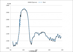
There are gauging stations on the rivers, and each station has a device measuring the water level and the flow speed. A mathematical model, that monitors how the water flows and the character of precipations, was created. Our development solves the inverse problem: according to observations data, a model of river channel volume and its roughness is built. We do not need to scan anything, the measurements of the water level and the water discharge are enough. After the researches are conducted, we can forecast floods with high accuracy, using this model.